2010ASLA景觀專業獎|規劃與分析榮譽獎:Isla Palenque
點擊進入“2010美國景觀設計師協會(ASLA)專業獎”專題
“The concept is effective and comprehensive. It combines the sustainable resort and eco-tourism. As part of the ecotourism concept, it seems that they spoke to the people who live there and the solutions were developed from their culture, which is very important.”
“The concept is effective and comprehensive. It combines the sustainable resort and eco-tourism. As part of the ecotourism concept, it seems that they spoke to the people who live there and the solutions were developed from their culture, which is very important.”
—2010 Professional Awards Jury
Isla Palenque, a 434-acre Panamanian island, serves as a model for geo-responsible design practices throughout Central America, drawing upon natural, human-made and cultural patterns. The project preserves 85 percent of the island into a nature sanctuary, examines bioclimatic strategies for site-planning decisions, explores methods of agrotourism to decrease imports, and develops water and energy management plans that reduce dependency on nonrenewable resources. The project challenges existing governmental regulations, redefining regional development and conservation standards.
評語:“這個概念周全,有效。成功地結合可持續度假和生態旅游。作為生態旅游概念的一部分,它們與當地居民產生對話,并從他們的文化中到了解決方案,這是非常重要的。”
-2010專業獎評審委員會
項目概述:Isla Palenque是一個面積為434英畝的巴拿馬海島,當地希望憑借自然、人工和文化力量,將此島建設成中美洲富有地域責任的設計實踐案例。項目保存85%的土地規劃為自然保護區,通過考量當地生物,氣候條件決定選址和規劃,通過農業旅游業來減少進口,通過水源、能源的發展減少對不可再生資源的依賴。此項目挑戰了現存的政府管制制度,重新定義了傳統區域發展的標準。
Project Goals
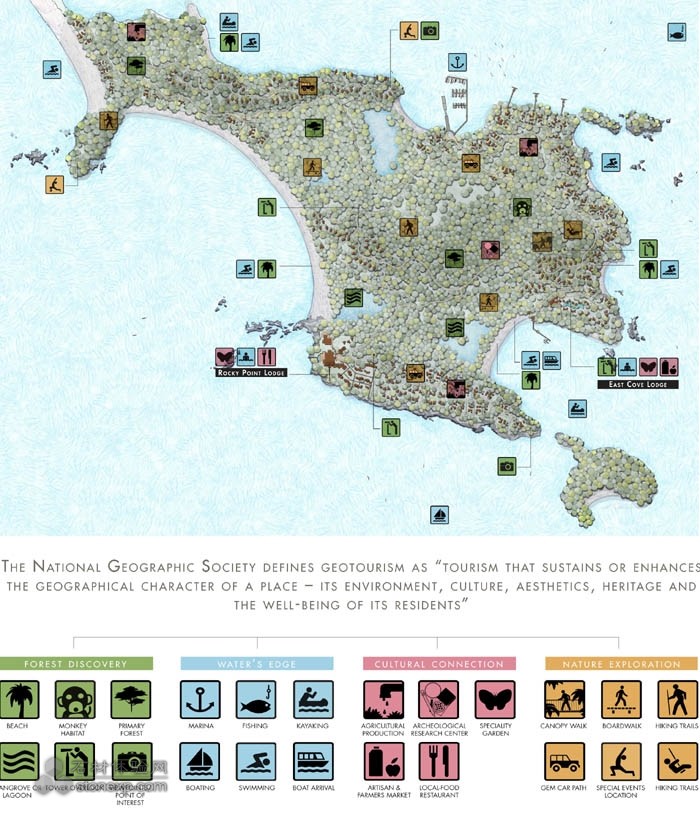
Islands hold a special place in our collective unconscious—places of mystery, discovery, isolation, adventure and, occasionally, danger. The mainland is where ordinary life occurs, but islands are special. Perhaps it was these inherent qualities that spurred the client to take a big step toward a dream he first hatched in college. Isla Palenque serves as the client's first geotourism project, whose vision was to develop a model for sustainable island planning that expressed the place's true spirit, or genius loci. With loose development regulations throughout Central America, the vulnerability of many pristine sites has fallen to deforestation, out-of-scale development and traditional man-made recreational activities, all causing environmental repercussions. The landscape architect was instrumental in helping the client achieve his vision by synthesizing aspects of sustainability, ecotourism, conservation and education. The project goes beyond the aspects of ecotourism. The National Geographic Society defines geotourism as "tourism that sustains, or enhances, the geographical character of a place—its environment, culture, aesthetics, heritage, and the well-being of its residents." Like ecotourism, geotourism promotes a virtuous circle whereby tourism revenues provide a local incentive to protect what tourists are coming to see, but extends the principle beyond nature and ecology to incorporate all characteristics that contribute to sense of place, such as historic structures, living and traditional culture, landscapes, cuisine, arts and artisans, as well as local flora and fauna.
Context
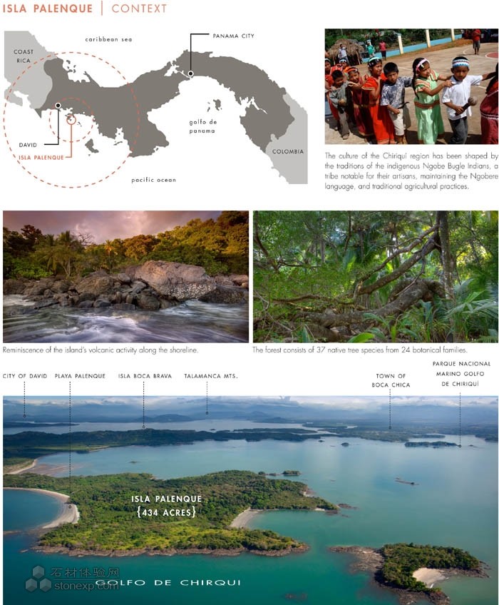
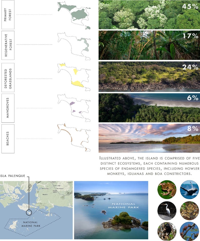
Isla Palenque is an ecological "jewel" nestled amidst an archipelago of national marine parks. Adjacent to the Parque Nacional Marino Golfo de Chiriquí, the region has coaxed trailblazing nature lovers to the area for years. However, tourism-friendly laws and tax incentives have opened the floodgates for investment in Panama. Since 2004, tourism arrivals have more than doubled, while tourism-based revenue has more than tripled. Isla Palenque is home to a handful of distinct environmental systems, including endangered species of flora and fauna. Primary forests shelter once-active volcanic hills; mangroves and marshes reside in lowlands; and grasslands, deforested by historic livestock production, are scattered along the perimeter where exotic zebra-striped beaches lie.
Process
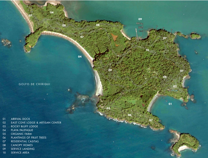
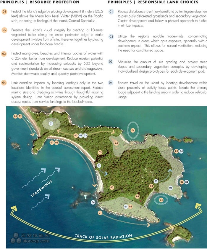
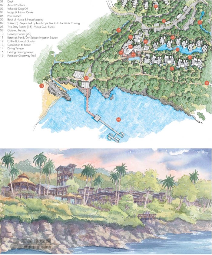
Developed in GIS, an ecozoning plan analyzes layers of environmental, social and economic conditions. However, it was multiple site visits with local environmental experts that provided the opportunity to investigate the island's spiritual quality. Each visit explored new parts of the island, offering the design team a fresh aspect. Interaction with the region's Ngobe-Bugle Indian tribe offered the team insight to cultural traditions, including patterns from their arts and crafts that influenced the project's architectural design. The design team drew upon these observations in order to develop a series of master plan conclusions related to coastal access, transportation, development, energy, open space and conservation. The coastal assessment identified two access points to the island. The deeper, north cove allows for a service marina, while the picturesque, east cove, welcomes guest arrival. Ridgelines are preserved and structures are nestled into the landscape to reduce visual impact. Development is concentrated on previously cleared areas along coastlines and facilitates passive ventilation. A centrally located service area, located on a flat area where the forest floor is relatively bare, is adequately screened. The island's fragile forests, lagoons and mangroves—
approximately 95 percent of the island—are preserved as a nature sanctuary for the public.
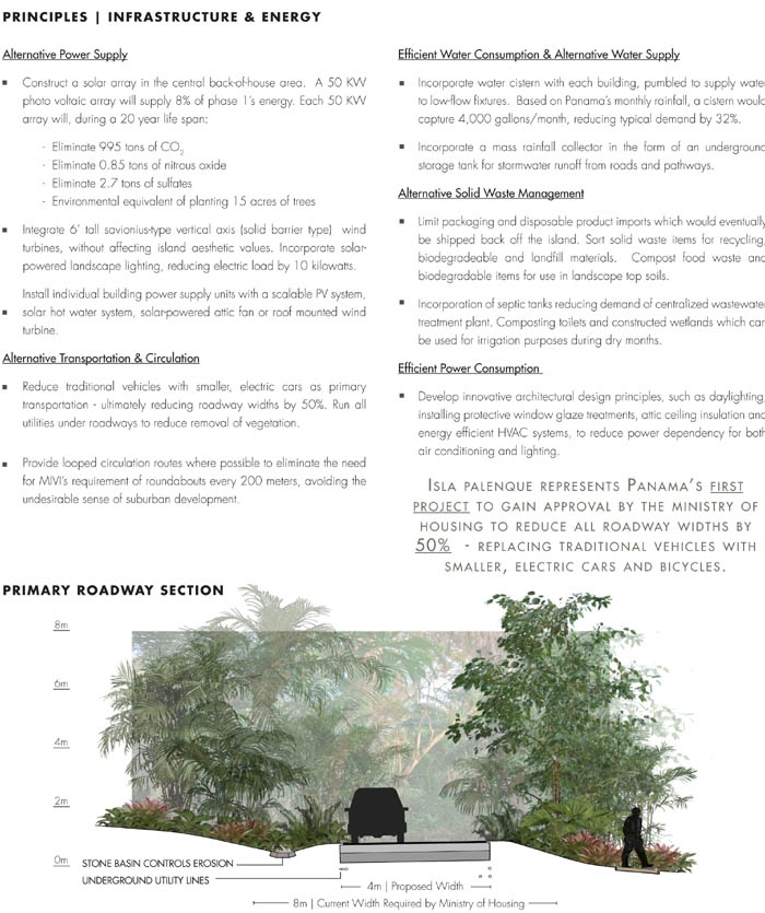
Isla Palenque also represents the first known project to gain approval for roadway-width reduction by Panama's Ministry of Housing. The island's intimate scale and varying topographic conditions supported the design team's vision for alternative transportation. In lieu of traditional vehicles—which would result in extensive grading—a fleet of smaller, electric cars would serve as the island's primary mode of transportation. Typical roadway widths are reduced by 50percent, decreasing site disturbance, emissions, construction cost and infrastructure needs.
Bioclimatic Design Strategies
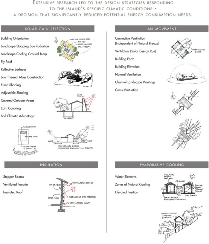
Collaboration between the landscape architect and design team resulted in bioclimatic strategies that utilize the island's tropical climate to reduce energy needs. Strategies revolve around air movement, insulation, solar gain rejection and evaporative cooling. Building orientations are balanced perpendicular to the prevailing winds of dry and wet seasons. Landscape enhancements channel breezes into buildings elevated off the ground, allowing cross ventilation. In tropical environments, the east and west aspects receive the strongest sun at the lowest angle. Therefore, the design team orientated the short sides of buildings in these directions, positioning landscape to further shade. Exterior planted terraces replace paving to reduce ground temperatures. Bodies of water are placed immediately outside openings to pre-cool air entering the house. Rainwater harvesting techniques, including collection cisterns and towers, are celebrated and incorporated into the architecture and later reused in the landscape.
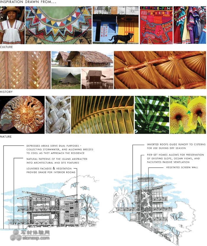
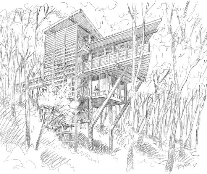
The architectural heritage of Panama is highlighted through the site planning of residential casitas, designed as a cluster of small buildings, imitating the form of nearby villages. Casitas, consisting of modular kit of parts, have the ability to be rearranged to preserve notable trees. The villagelike design enables the architecture to follow grade, with all rooms opening onto courtyards. Steep slopes and high canopy forests required the development of an alternative residential product design. Elevated canopy homes, connected by a series of raised boardwalks, preserve existing grade and vegetation. Ocean views project from the top floor, as the building approaches the canopy. Inverted roofs collect and divert water to cisterns.
Agrotourism and Education
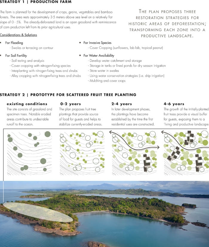
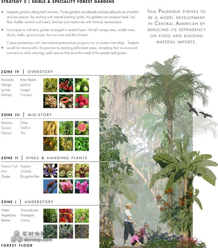
The team recognized the constraint and expenses of importing food and building materials to the island and developed an agrotourism program that proposes three mitigating actions: an organic production orchard, an edible forest garden and the scattered plantings of fruit trees. The program was adapted to the local environment under the guidance of local farmers. Residents will grow much of their own produce in community gardens. Deforested lands are utilized for the growth of building materials, including palm leaves for thatch and bamboo for furnishings. Orchid and bromeliad specialty gardens offer public interest, planned in appropriate microclimates. Along the southern hammerhead where historic livestock activities once occurred, fruit trees will be planted and allowed to mature in order to screen future residential casitas. Until then, tree roots help stabilize the deforested land and provide produce for residents.
Socially conscious, the master plan fosters educational development to three user groups; local citizens,island guests and international academic institutions. First, education and quality of life will be improved for nearby Chiriquí citizens through professional development programs, housing and employment. Local artisan studios are integrated into the village. Interpretive trails and local guides help to educate visitors to the island's sustainable practices, flora and fauna, history, and local customs of the nearby Ngobe Bugle tribe. Finally, the island's agricultural focus presents opportunities for international exchange programs with university horticulture curricula. Students would be introduced to the practice of permaculture by restoring deforested areas, ultimately learning how agricultural systems relate to natural ecologies.
Environmental Sensitivity and Sustainability
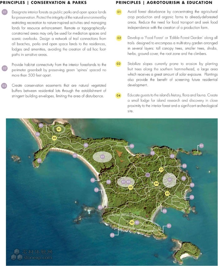
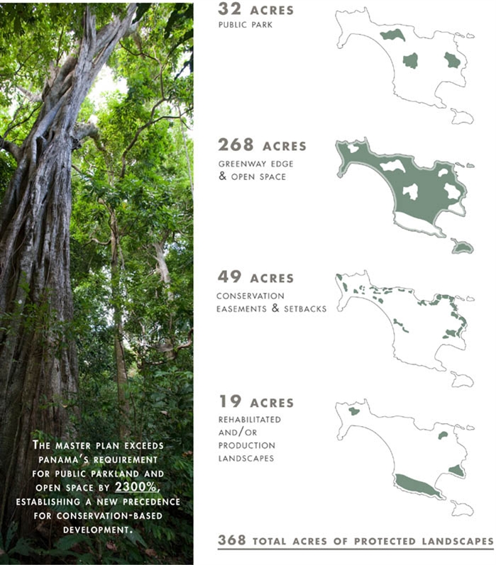
Isla Palenque will serve as a model for ecoresponsible design and practices by taking a holistic approach to sustainability. Upon complete build out, less than 15 percent of the 434 acres will be built upon, including all buildings, roads and trails. Panamanian law requires 15 percent of all zoned land to be designated for park and open space purposes. The proposed plan exceeds this requirement by over 2300 percent, preserving 368 acres for the enjoyment of its visitors. A greenway circumnavigates the island, buffering views. Over six miles of nature trails extend into the island's interior, where bird-watching towers, interpretative trails and play areas created from natural materials found on the island replace any notion of traditional urban play structures. The synthesis of the island's environmental features creates an unparalleled recreational program.
95 percent of the planned development's energy needs is generated by on-site solar and wind power. Utilities, laid under roadways, further reduce the need to remove vegetation. Water collection systems reduce dependency for extracted water by collecting rainwater during the wet, summer season. Roadways consist of crushed volcanic rock, extracted from already deforested areas. Native plants will reduce dependency on irrigation during the wet season, while on-site wastewater treatment and cisterns provide irrigation during the dry season. Food waste is converted into compost, used later at the farm. Sustainability efforts are planned to culminate with the anticipation of third-party ecotourism programs and USGBC LEED® Platinum certifications for all public and residential buildings.
Future
The landscape architect facilitated a phased and flexible implementation over a 10-year period, looking holistically at development, circulation, energy, conservation and amenities. By introducing new prototypes to the market, the plan accommodates for market demand flexibility, ensuring an economically sustainable future. As the first ecotourism island destination in Panama's Chiriquí region, phase one of Isla Palenque is nearing the implementation stage, slated to open in 2012.
O項目目標
島嶼在我們大家的潛意識里是一個非常特別的地方,集神秘、發現、孤獨于一身,偶爾還帶有危險性。大陸上是普通人生活的地方,但是島嶼非常特別。或許是這些內在的特性激發了客戶,讓他們敢于采取行動來實現自己大學時代就已經孕育的夢想。巴拉馬成為客戶的第一個地質旅游項目,其目的是為可持續的島嶼發展樹立一個模板,以期能表現出該地區的真正精神。由于整個中美洲實行的松散的發展規劃,很多原始遺址極易受到破壞,淪為森林砍伐、毫無節制的發展和傳統的人造娛樂活動的犧牲品,所有這一切都對環境造成了不良影響。園林設計師可以通過整合可持續性、生態旅游、環境保護和教育等方面來幫助客戶實現他的夢想。這一項目遠不止是為了生態旅游。美國國家地理協會給地質旅游下的定義是“能夠維護或者增強一個地方的地理特征——它的環境、文化、美學、遺產以及其居民的康樂的旅游”。像生態旅游一樣,地質旅游能夠促進一個良性循環,借此,旅游的收益可以用來激勵當地人保護游客們想來看的東西,但同時也擴展了超越自然和生態的原則,以便來綜合各種能夠提供地域感的特征比如歷史建筑、生活和傳統文化、風景、烹飪、藝術和工匠以及當地的動植物。
O環境
巴拉馬群島是一顆生態“寶石”,坐落在國家海洋公園的一處群島之中。它毗鄰奇里基海灣的國家海洋公園,多年來已經吸引了具有開拓性的自然熱愛者來到這里。然而,旅游友好型的法律和稅收鼓勵已經為在巴拿馬投資打開了大門。自2004年以來,來旅游的人增加了一倍,而旅游收益卻增加了兩倍。巴拉馬群島是一些獨特的環境系統的發源地,包括瀕危動植物物種。原始森林覆蓋著曾經活躍的火山;紅樹林和濕地坐落在低矮的地域;歷史上被牲畜破壞的森林而形成的草地散落在群島周圍,這里有著奇異的斑馬紋狀的海灘。
過程
基于地理信息系統的發展,一項生態規劃計劃分析了這里多層次的環境、社會和經濟條件。然而,是當地環境專家們對此地進行的多次拜訪為考察這個島嶼的精神特質提供了機會。每次考察都會發現該島嶼的一些新領域,為設計團隊提供了一個全新的視角。與該地區Ngobe-bugle印第安部落的交流互動為設計團隊提供了對文化傳統的洞察力,包括他們的工藝品的圖案,這些都對該項目的建筑設計產生了影響。設計團隊把觀察到的這些進行了匯總,以便繪制一系列的最終藍圖,這些藍圖與沿海入口、交通、發展、能源、開放空間和環境保護息息相關。對沿海的評估確定了兩條通往該島嶼的路徑。較深的北部海灣能夠容納一個服務用的碼頭,而風景如畫的東部海灣可用來歡迎到來的游客。屋脊被予以保留,建筑隱藏于風景之中以便減少視覺上的影響。該島嶼的發展重點是海岸線上之前的空白區域,以促進被動通風。一個位于中心地帶的服務區被恰當地畫到了平面圖上,這個服務區坐落在一個平坦的區域,這里的森林地被非常貧瘠。該島嶼脆弱的森林、環礁湖和紅樹林——大概占該島的95%——被予以保留,成為公眾的一處自然避難所。
巴拉馬群島也是目前第一個獲得巴拿馬住房部同意的減少路面寬度的項目。該島緊密的規模和多變的地形條件為設計團隊要實現替代交通的夢想提供了支持。要替代傳統的交通工具——這會導致大范圍的坡度緩和工作——一隊較小的電車將被用做該島主要的交通工具。典型的道路寬度被縮減了50%,減少了建筑物的干擾、排放物、建造成本和基礎設施需求。
O生物氣候設計戰略
園林設計師和設計團隊之間的合作催生了生物氣候戰略,即利用該島的熱帶氣候來減少能源需求。該戰略圍繞空氣流動、隔離、拒絕吸收日光和蒸發式冷卻進行。建造方向將與干季和濕季盛行的風保持垂直,并使之保持平衡。該島的自然景觀促使來自海灣的微風吹進地勢較高的建筑物里面,實現了對流通風。在熱帶環境下,東面和西面在最低的角度下可以接受最強的光照。因此,設計團隊將建筑物較矮的一側移向這些方位,把自然景觀進一步推后。外部種植的梯田替代了塊石路面,以此來減少地表溫度。很多蓄水池立即被放置在了外面的空地上,來預先冷卻進入房子里的空氣。雨水收集技術,包括蓄水箱和水塔,被融進了建筑物里,之后在自然景觀中被再次利用。
在該島的民用小屋的規劃過程中,巴拿馬的建筑遺產被發揮到了極致。這些房子模仿附近村子的形式,被設計成了較小的建筑群。這些小屋是由模塊化的部分構成的,它們能夠被重新安排以便保護那些著名的樹木。村落式的設計使得建筑式樣能夠跟上檔次,所有的房間都面向庭院敞開。陡峭的斜坡和高大的穹廬般的森林需要開發一種住宅替代品。由一系列吊起來的木板路連接起來的地勢較高的蒼穹式房屋可以保存現存的等級和植被。從頂層可以觀看到海邊的景色,因為建筑物接近蒼穹。倒置的屋頂收集并把水轉移到蓄水池里。
O農業旅游和教育
設計團隊認識到了從外界進口食物和建筑材料到島上存在的局限和代價,于是開發了一個農業旅游項目,提出了三項緩和措施:一個有機產品果園,一個可食用的森林花園以及大量種植果樹。在當地農民的指導下,這一項目適應了當地的環境。居民們將在社區的花園里大量種植自己的農產品。森林被砍伐的土地被用來種植建筑用的材料,包括用來蓋屋頂的棕櫚樹葉和家居裝修用的竹子。果園和種植鳳梨的專門花園引起了公眾的興趣,計劃將在適宜的小氣候中進行。該島南部的垂頭狀部位曾是歷史上飼養牲畜的地方,這里將會種植果樹,并讓它們長大以便用來遮掩未來的居民小屋。到那時候,樹根會幫助穩固被砍掉森林的土地,并為當地居民提供農產品。
該藍圖還有很強的社會意識,它把教育開發的培育分為三個使用者群體:當地居民,島上的來客和國際學術機構。首先,通過專業的發展項目、住房和雇用員工,奇里基市民的教育和生活質量將被提高和改善。當地的工匠作坊將被整合到村子里面,帶有解釋功能的小路和當地導游將幫助游客們認識島上可持續性的做法以及動植物、歷史和附近Ngobe Bugle部落的風俗習慣。最后,該島上的農業中心為與大學的園藝課程進行國際交流項目提供了機會。通過復原森林遭砍伐的區域來進行永久培養的做法將被介紹給學生們,使他們最終明白農業系統是如何與自然生態環境相關聯的。
O環境敏感性和可持續性
通過采取一種整體措施來實現可持續性,巴拉馬群島將會成為對生態負責的設計和做法的典范。等擴建完全建好之后,434英畝的土地中有不到15%將被用來進行建筑施工,包括房屋、公路和小徑。巴拿馬的法律要求所有被劃定的區域中的15%可以用來建造公園和露天場所。擬好的計劃超出了這項要求的2300%還多,留出了368英畝的地方來供游客們娛樂。一條林蔭大道環繞著該島。超過6英里的自然小路延伸進該島的內部,在這里有觀鳥塔、具有解釋功能的小路和娛樂場所,這些都是用在島上發現的天然材料建成的,這一切取代了任何一個傳統的城市娛樂設施的架構概念。對島上環境特點的綜合運用產生了一個無與倫比的娛樂項目。
擬定的發展規劃的能源需求中有95%是由現場的太陽能和風能來產生的。被放置在道路底下的公共設施會進一步減少移動植被的需要。采集水的系統減少了對通過在潮濕的夏季收集雨水來提取水的依賴性。道路是用粉碎了的火山巖石鋪成的,是從早已遭砍伐的地方提煉出來的。在雨季,本地生植物將減少對灌溉的依賴性,而現場的廢水處理和蓄水池會在旱季里為它們提供灌溉。廢掉的食物將被轉化成混合肥料,之后被用在農田里。隨著第三方生態旅游項目的可能加入以及可能獲得美國綠色建筑協會的LEED認證(該認證適用于所有公共建筑和居住建筑),可持續發展的努力將被達到頂峰。
未來
園林設計師一直分階段地靈活促進著這項為期10年的計劃的實施,以歷史的眼光關注著發展、循環、能源、保護和舒適。通過把新的標準引入市場,該計劃會隨著市場需求靈活調整,這就保證了會有一個經濟上可持續的未來。作為巴拿馬奇里基地區第一個生態旅游島嶼,巴拉馬的第一期工程已接近實施階段,定于2012年開始動工。
[page]
1 .Isla Palenque, a 434-acre island off Panama’s Pacific coastline, will serve as a model for geo-responsible design and practices throughout Central America by drawing upon the natural, human-made, historical and cultural patterns of the region.
Isla Palenque是一個面積為434英畝的巴拿馬海島,當地希望憑借自然、人工和文化力量,將此島建設成中美洲富有地域責任的設計實踐案例。
[page]
2 Context. The island is only accessible by boat, either from David or the fishing village of Boca Chica. Recent improvements to the notable Pan-American Highway and David International Airport have made the Chiriquí region a highly desired destination for international tourists.
無論從哪,到達島上只能靠小船。最近修的國際機場和公路已經顯著改善這一區域情況,使其成為國際旅客非常理想的目的地。
[page]
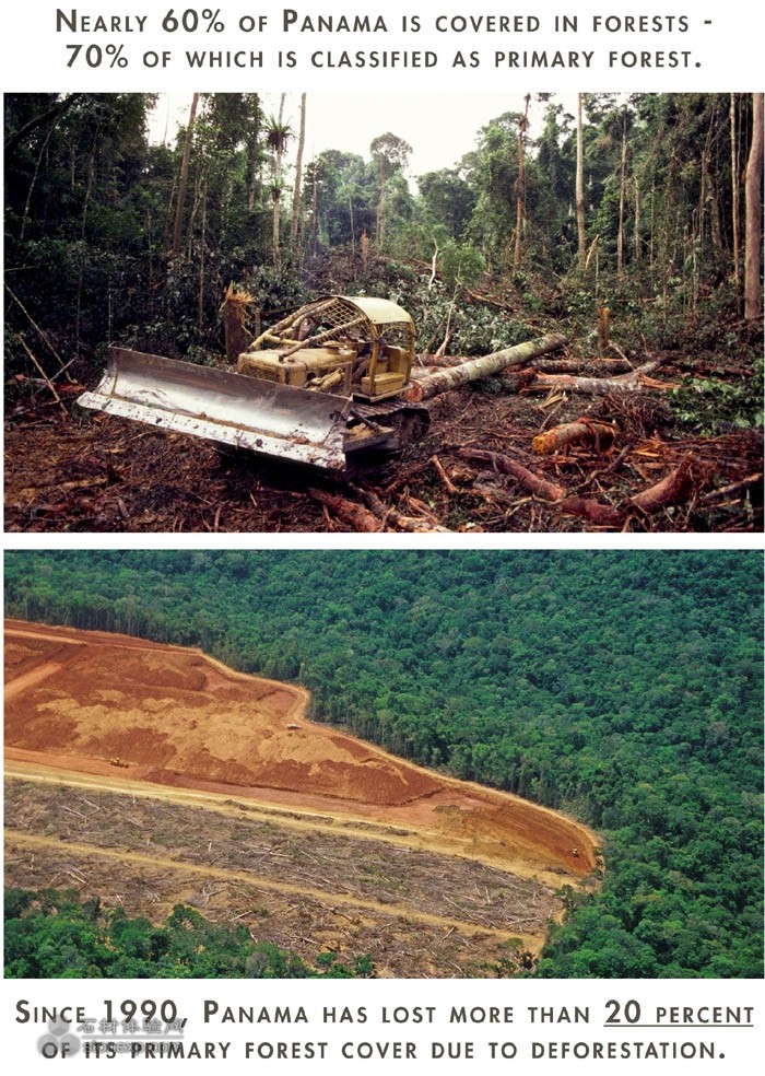
3 Effects of Deforestation. Nearly one-quarter of Isla Palenque has witnessed the devastating effects of deforestation, an industry which has significantly harmed Panama's ecosystems. The master plan reestablishes the island's environmental integrity, rehabilitating damaged landscapes for future generations to enjoy.
森林砍伐的影響。這是最近一季度島上砍伐森林所造成的破壞性影響,巴拉馬產業生態鏈嚴重受挫。總體規劃重新建立島內環境的完整性,回復受損景觀,澤被后世。
[page]
4 The master plan reestablishes the island's environmental integrity, rehabilitating damaged landscapes for future generations to enjoy. Distinct ecosystems provided insight to the island's ecological framework.
生態系統分析。在全國范圍內對19個島嶼和25個珊瑚礁進行采樣,這里海陸生物異常多樣化。非凡的生態系統成為島上生態框架。
[page]
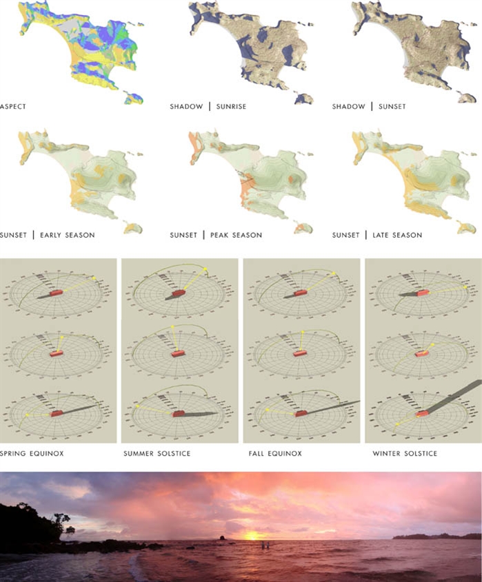
5 Solar Analysis. The process began with an in-depth analysis of environmental, social and economic conditions to create an ecozoning plan. In particular, understanding the site's solar-orientation patterns enabled the team to site architectural elements based on notable views and daylighting opportunities.
太陽能分析。基于對社會和經濟的考慮而深入分析環境。了解場地太陽照射模式后,為建筑設計打下了基礎。
[page]
6 Conclusions from Analysis. From the analysis, the team extracted principle conclusions for multiple categories that were later incorporated into the master plan. Preserving the island's environmental integrity took on the highest priority, limiting developing to only 15percent of the island's coverage.
經分析,研究小組指定多個類別的氣話,其中島上的環境完整性最優先,只有15%的區域可以建設。
[page]
7 Bioclimatic Design Strategies. Collaboration between the landscape architect and design team resulted in bioclimatic strategies that utilize the island's tropical climate to reduce energy needs. trategies revolve around air movement, insulation, solar gain rejection and evaporative cooling; aligning the vision of all disciplines.
生物氣候策略。景觀設計師和整個設計團隊共同制定升武器后戰略,利用當地熱帶氣候減少對能源的需求。科學的利用空氣流動,保溫,太陽能增益及蒸發冷卻。
[page]
8 Conclusions from Analysis. Under current Panamanian law, 15 percent of the 66 developed acres [which equates to 16 acres] must be reserved for public parkland. The master plan doubles this requirement and goes beyond to preserve 336 additional acres in conservation.
結論:巴拿馬的法律要求所有被劃定的區域中的66個發達區的15%,大約16英畝用于公共綠地。擬好的計劃超出了這項要求,超出了336英畝。
[page]
9 Conservation Framework. The master plan for Isla Palenque proposes a framework for the conservation of the island’s environmental systems.
保護框架。總體規劃為島嶼提出了一個系統框架,保護島嶼環境。
[page]
10 grotourism Strategies for Deforested Lands. Farm production established in areas of historically deforested areas is adapted to the various microclimates. Solar aspect, slope, salt exposure and bedrock depth were strong factors for consideration of production farm locations.
農業旅游區的選擇在森林砍伐區,綜合考慮了各種微氣候,光照,坡度,鹽堿度,土壤肥力,厚度等各種影響生產的要素。
[page]
11 Enhancement of Living Zone. Recognizing the constraint and expense of importing building material and food, an extensive agrotourism program identifies opportunities for edible forest gardens. Gardens aim to foster educational development to three user groups: local Chiriquí citizens, island guests and international permaculture programs.
生活緩沖區:設計團隊認識到了從外界進口食物和建筑材料到島上存在的局限和代價,于是開發了一個森林中的農業旅游項目。教育開發針對三個使用者群體:當地居民,島上的來客和國際學術機構。
[page]
12 Conclusions from Analysis. A comprehensive water and energy budget was developed for each project phase, comparing typical versus efficient demand to reduce dependency on utility services. 95 percent of projected energy needs will be generated by on-site solar and wind power.
在項目的每個階段都考慮水和能源的利用率,減少對工具的依賴,場地中95%的能源都將通過太陽能和風能生產。
[page]
13 Geotourism Planning. Envisioned a "geotourism" destination, Isla Palenque will engage travelers in historical, archeological, architectural, natural and cultural experiences. Designers aimed to create a holistic experience that focuses on the “place as a whole.”
地質旅游規劃。設立地址旅游目標,使游客得到歷史,考古,建筑,自然,文化方面的體驗,這個整體觀感是設計師“著眼于宏觀”而力求創造的。
[page]
14 Vernacular Precedent. A photographic essay, documented over multiple site visits, influenced proposed site planning and design vocabularies.
前述的鄉音。一個攝影文章,記錄訪問多個地點,并影響到后來的選址和設計語匯。
15 Vernacular Precedent. Striving to honor the land and Panamanian culture; architectural patterns and forms take their cues from the region’s cultural, natural conditions and historical past.
前述的鄉音。尊重巴拉馬土地和文化,建筑的格局和形式傳承歷史延續文化,符合自然條件。
[page]
16 Site Planning in Response to Topography. Nestled into the jungle landscape, canopy homes were envisioned as light and airy structures elevated above the ground, responding to the given landform. om their lifted position, structures capture tradewinds and ocean views without compromising the integrity of the natural landscape.
響應場地的設計。構筑成為景觀的一部分,高架起來以便通風,并克服地形,屋頂像樹冠一樣耀眼。所在位置恰到好處的捕捉大海過來的風,又保證不被風暴傷害。
17 East Cove Lodge. Rather than the traditional resort environment where guests have an isolated experience, the design and program facilitates a sense of community by providing centrally located open spaces and a Panamanian-inspired lodge where guests interact with skilled artisans and enjoy island-grown foods.
東灣別墅,非傳統的度假環境,給客人一個不一樣的經驗。設計和計劃促進了當地的社區意識,提供位于最集中的休憩用地,當地人為客人嫻熟服務的,還能享受當地服務。
版權聲明:
? 凡注明“石材體驗網”的所有文字、圖片、音視頻、美術設計和程序等作品,版權均屬石材體驗網所有。未經本網授權,不得進行一切形式的下載、轉載或建立鏡像。
? 您若對該稿件內容有任何疑問或質疑,請即與體驗網聯系,本網將迅速給您回應并做處理。
點擊右側【在線咨詢】或至電0769-85540808 處理時間:9:00—17:00
石材體驗網部份作品均是用戶自行上傳分享并擁有版權或使用權,僅供網友學習交流,未經上傳用戶書面授權,請勿作他用。